It often happens that developments are made during a project that are ultimately not needed. Regardless, these unnecessary developments can be inspiring. Here is an example...
In our work, we often create unnecessary things that will not be needed later, such as design elements or programs and functions created during development.
Maps as artistic elements
While designing and developing a website for one of our clients, we wanted to make the company’s very impressive maps dynamic and interactive. We thought about using the style of the maps for other graphic displays as well.
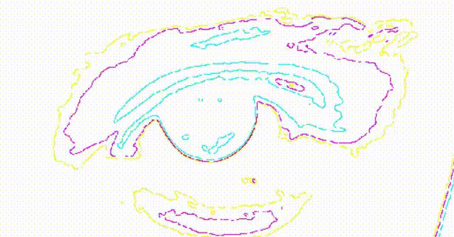
We thought that the contour lines used on the maps could be used for other things, such as tools, landscapes, or even human faces.
We conducted several experiments to convert raster images with complex textures into contour maps.
The animation schematically shows how the raster points are transformed into lines. In the case of contour maps, care must also be taken to ensure that the lines do not cross each other.
I will not describe the details of the algorithm, as many aspects still need to be fine-tuned, but we will publish one experimental result. In the experiment, a contour map was created from a portrait of Greta Thunberg.
We have uploaded the result to the pixabay website so that others can use it.
Tibor J. Mozes
Developer at SciArt Agency. He enjoys data visualization tasks, especially map visualizations. He holds degrees in geography and geology and completed his doctoral studies in geothermal energy and sustainable water management.
SciArt Agency has joined the Erasmus+ KAI22 VET Programme
We value your privacy
We use cookies to enhance your browsing experience, serve personalised ads or content, and analyse our traffic. By clicking “Accept”, you consent to our use of cookies. Cookie Policy